
Advanced 3D Mapping
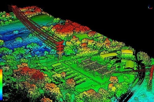
LiDAR Terrain & Canopy Modeling
See the landscape in 3D like never before. Our LiDAR technology penetrates dense canopy to deliver precision data for smarter agricultural decisions.
See the landscape in 3D like never before. Our LiDAR technology penetrates dense canopy to deliver precision data for smarter agricultural decisions.
LiDAR (Light Detection and Ranging) uses laser pulses to create millions of precise data points, generating detailed 3D maps of terrain and vegetation. Unlike traditional imaging, LiDAR penetrates dense canopy to capture ground elevation and structure beneath.
Precise elevation data for irrigation planning, drainage analysis, and precision grading. Identify low spots and water accumulation before problems occur.
Volume calculations for spray optimization, growth tracking over seasons, and identifying areas of vigor or stress within orchards and vineyards.
Site assessment for new plantings, row spacing optimization, and infrastructure planning for trellis systems and irrigation layout.
Multi-year data comparison reveals trends in growth patterns, canopy changes, and yield potential. Make data-driven decisions backed by historical precision.
Verify existing row widths for equipment compatibility, identify compaction zones, and optimize pathways for harvest and maintenance vehicles.
Model how water moves across your property to optimize irrigation design, identify drainage issues, and improve overall water management.
From almonds to wine grapes, our LiDAR services support a wide range of California crops.
Almonds, walnuts, pistachios, and citrus benefit from canopy volume analysis for spray optimization, pruning guidance, and yield estimation.
Wine grapes, table grapes, and raisins benefit from precision row mapping, erosion analysis, and frost pocket identification.
Site assessment for new orchards and vineyards including soil moisture patterns, sun exposure modeling, and infrastructure layout.
Build a multi-year data library to track growth trends, identify underperforming blocks, and make informed decisions backed by precision data.
Every LiDAR survey includes actionable deliverables you can use immediately. Our data integrates with common farm management software and can be shared with your agronomist or consultant.
Comprehensive PDF with key findings, recommendations, and visualizations
Digital maps with layers for elevation, canopy, and water flow
Full resolution .LAS/.LAZ files for further analysis or archiving
Export-ready models for CAD/GIS integration
Million data points per survey
Vertical accuracy
Acres per flight hour
Delivery turnaround
Data retention
Contact us today to discuss how LiDAR terrain and canopy modeling can help optimize your agricultural operations.